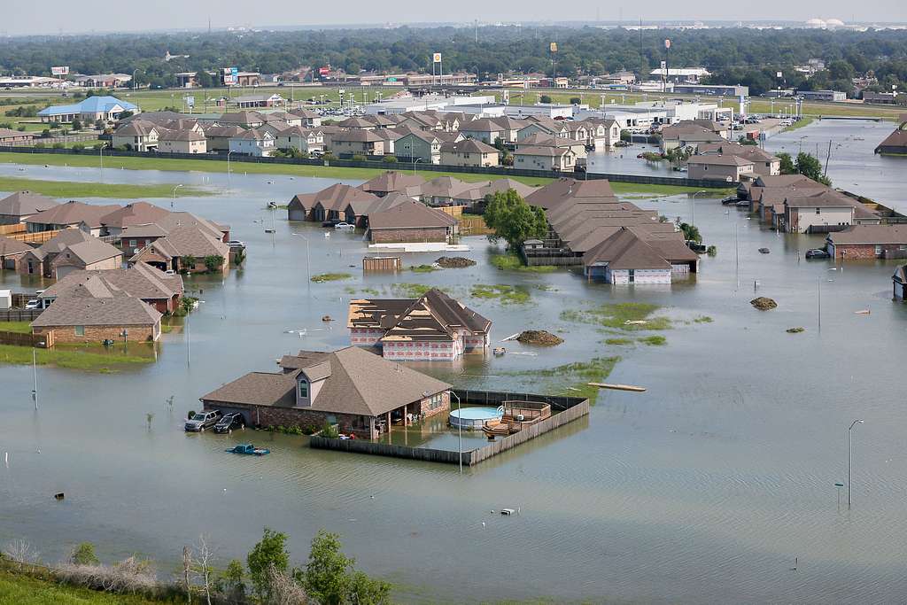
Flooded landscape in Texas
Introductory Briefing

Flood Emergency Warning System (FEWS)
for Montgomery County

An introductory briefing for Montgomery County stakeholders — connecting rural upstream watersheds to downstream communities through Corvalent's CorGrid platform, under Texas DIR Contract DIR-CPO-6230.

2026 Joe Trujillo — Chief Executive Officer, Projexel LLC
Projexel Corvalent TALON Technical Sales BLCCS
Montgomery County Smart Flood Warning — Briefing Podcast Montgomery County
0:00 --:--

Context

Understanding the Texas Flood Emergency Warning System Solutions

Flood risk is a regional and interconnected challenge: rainfall and water-level changes often begin upstream before affecting downstream roads, crossings, and critical facilities. An effective Flood Emergency Warning System connects upstream and downstream data into one common operational picture of conditions, trends, thresholds, and asset health.

The D.H. Collective LLC is the prime contract holder for Texas DIR Contract DIR-CPO-6230, Flood Early Warning Systems Technology Solution Products and Related Services. The contract runs June 4, 2026 through June 4, 2031, giving eligible public entities a cooperative path to purchase directly from The D.H. Collective. Official page: dir.texas.gov/contracts/dir-cpo-6230.

The FEWS partner ecosystem: The D.H. Collective (prime), Projexel (labor & systems integration), Corvalent's CorGrid (sensing, telemetry & analytics), TALON Technical Sales (sensors), and BLCCS (software & dashboards).

5
Integrated Ecosystem Partners
D.H. Collective, Projexel, Corvalent, TALON & BLCCS
DIR-CPO-6230
Active Texas DIR Contract
June 4, 2026 – June 4, 2031
1
Single Pane of Glass
for Flood Intelligence

SOURCES: Texas Department of Information Resources: DIR Contract DIR-CPO-6230 / RFO DIR-CPO-TMP-608 (dir.texas.gov/contracts/dir-cpo-6230); Deloitte Smart Cities & Urban Transformation; McKinsey & Company: Smarter Cities Are Resilient Cities.

About The CorGrid Platform

Corvalent's modular, scalable IoT platform for industrial and public-sector monitoring.

Corvalent

32 years of IoT & AIoT experience

Corvalent is an American technology company specializing in industrial-grade IoT and AIoT solutions, combining hardware, communications, software, and analytics into integrated Technology-as-a-Service ecosystems for automation, asset monitoring, and real-time data management.

CorGrid

Flood-intelligence single pane of glass

CorGrid is the central intelligence layer connecting sensors, gateways, and workflows. For FEWS, it unifies rainfall, creek/river levels, rate of rise, reservoirs, low-water crossings, and device health — supporting SaaS, on-premises, and hybrid deployments that integrate with existing infrastructure.

Proposed Solution

How the Smart IoT Solution Strengthens Flood Preparedness

01

Integrated Rural Upstream and Urban Downstream Monitoring

Rain gauges, creek-level sensors, and reservoir instrumentation upstream are correlated with downstream channels, crossings, roads, and critical facilities — a connected watershed view rather than isolated points.

02

A Single Pane of Glass for Flood Intelligence

CorGrid consolidates telemetry from multiple sensor brands and jurisdictions into one operational view of conditions, warnings, device status, and risk areas — accessible from any modern browser.

03

Automated Thresholds, Escalations & Response Workflows

Configurable rules evaluate rainfall, water levels, and equipment status, triggering tiered alerts routed to the right personnel by location, severity, and jurisdiction.

04

Low-Water Crossing, Road & Critical-Infrastructure Protection

Water-level sensors, cameras, and beacon status connect to CorGrid to trigger alerts, update dashboards, and activate warning equipment at crossings, bridges, and pump stations.

05

Predictive Asset Maintenance & System Readiness

Continuous monitoring of connectivity, battery level, and device health helps teams act before a sensor fails, prioritizing field visits by risk.

06

Historical Analysis & Continuous Improvement

Historical rainfall, water-level, and incident data support post-event analysis, infrastructure planning, grant applications, and future expansion.

Key Technologies

Technology Stack and Architecture

Water-Level & Flow Monitoring

Radar, ultrasonic, and pressure sensors continuously measure water levels in creeks, reservoirs, and crossings, with rate-of-rise analysis beyond a simple threshold.

Rainfall & Weather Monitoring

Rain gauges and compact weather stations provide localized precipitation data, combined with water-level readings to track evolving watershed conditions.

Multi-Network Telemetry

Cellular, radio, LoRaWAN, and satellite links are selected according to coverage, bandwidth, terrain, and resilience needs.

GIS Mapping & Geospatial Intelligence

Sensors, watersheds, roads, and risk areas are mapped geographically, showing not only what is happening but where — and which downstream areas may be affected.

Artificial Intelligence & Advanced Analytics

Analytics identify abnormal patterns and correlate rainfall with water-level response, augmenting rather than replacing expert judgment.

Integrated Public Warning & Communications

CorGrid supports integration with approved notification, dispatch, and public-information systems — from field detection to coordinated communication.

Cybersecurity & Data Governance

Role-based access, secure communication, and full auditability are essential components of a public-sector IoT environment.

LoRaWAN Cellular Satellite Radar / Ultrasonic Sensors GIS AI / ML Analytics Multi-Network Telemetry

Expected Benefits

Tangible Outcomes for Texas Communities

Operational Efficiency

A unified platform gives emergency management, public works, and public-safety teams a consistent view of developing conditions.

Earlier Flood Awareness

Upstream monitoring can provide added lead time before downstream roads, neighborhoods, and infrastructure are affected.

Predictive Maintenance

Continuous device-health monitoring identifies weak batteries and degraded sensors before severe-weather events.

Infrastructure Management

Flood information connects to roads, bridges, drainage systems, schools, and emergency facilities.

Resource Optimization

Geographic risk information helps agencies prioritize field inspections, road closures, and emergency personnel.

Sustainability & Resilience

Historical and real-time data supports informed infrastructure investments and long-term community resilience.

Safety & Compliance

Automated alerts and auditable event histories support consistent, accountable emergency procedures.

Interagency Coordination

Shared dashboards let multiple departments and jurisdictions collaborate from the same operational picture.

Scalable Smart-City Foundation

The same CorGrid environment can later incorporate additional capabilities, including public safety and environmental monitoring.

Supporting Research

Research, Benchmarks and Innovation Potential

This initiative aligns with broader smart-city and resilience strategies. Modern urban transformation converges sustainability, digital modernization, AI, cybersecurity, and connectivity, with cities investing in real-time monitoring to reduce the effects of extreme weather.

Cities are encouraged to build a clear understanding of climate risk, incorporate it into planning, and implement early-warning systems — highlighting the role of technology and data in preventive action and long-term resilience.

The convergence of watershed monitoring, industrial IoT, geospatial intelligence, and coordinated emergency management is an important opportunity for Texas communities to modernize flood-preparedness, connecting rural upstream conditions with downstream urban consequences.

Applicable Insight

Communities can begin with a Discovery & Technical Alignment Workshop focused on priority watersheds and flood-prone corridors, validating an initial proof of concept before expanding across the full jurisdiction.

SOURCES: Texas DIR: Contract DIR-CPO-6230 / RFO DIR-CPO-TMP-608; The D.H. Collective: Texas FEWS Contract; Deloitte: Smart Cities & Urban Transformation; Deloitte Insights: Five Approaches for Climate-Resilient Cities; McKinsey: Smarter Cities Are Resilient Cities; McKinsey: Ensuring Adaptation and Resilience to Climate Change; NOAA / Natural Hazards Review: Economic Value of Flood Forecasts and Early Warning Systems.

Montgomery County: Next Prospect in Preparation

Engagement Status: Pre-Outreach Preparation

Montgomery County is currently in the pre-outreach preparation stage. Precinct-level information has been gathered to guide our approach, but the appropriate County point of contact (emergency management, precinct, or administrative) still needs to be validated before any county-specific materials name a contact or commit to meeting details.

Montgomery County is the next prospect we are preparing to assess for the FEWS program. Preparation is using the precinct information already provided, and we are working to validate the appropriate County contact before advancing outreach.

The County's growth, its position along the San Jacinto River watershed, and its mix of rural and fast-developing suburban areas make it a strong candidate for a connected flood-intelligence approach.

Discussion Focus Areas for Montgomery County

  • Priority watersheds and flood-prone corridors across County precincts
  • Existing monitoring and warning infrastructure
  • Low-water crossings and critical facilities most exposed to flood risk
  • Available funding sources
  • A sustainable, long-term maintenance model appropriate to the County's scale

Basin Sense IQ

Basin Sense IQ can later support discussions as a demonstration dashboard for reviewing public basin, gauge, and crossing information, once outreach is underway. It is a discovery tool, not an operational system of record.

REFERENCE: Montgomery County is a prospect in preparation; no County contact has yet been confirmed. Basin Sense IQ is a discovery/demonstration dashboard used to support discussion, not an operational system of record.

Partner Ecosystem

FEWS Partner Branding and Links

The Flood Emergency Warning System program is delivered by a coordinated ecosystem of specialized partners, each contributing a distinct capability to the overall solution.

01 — Prime & Contract Holder

The D.H. Collective LLC

Prime contract holder for Texas DIR Contract DIR-CPO-6230.

dh-collective.com
02 — Labor & Systems Integration
Projexel LLC

Projexel LLC

Provides labor and systems integration services for FEWS deployments.

projexel.org
CorGrid Platform
Corvalent

Corvalent

Delivers the CorGrid platform powering sensing, telemetry, analytics, and the single pane of glass.

corvalent.com
Sensor Partner
TALON Technical Sales

TALON Technical Sales

Supplies sensor hardware and technical sales support for field deployments.

talontechsales.com
Software & Dashboard Partner
BLCCS

BLCCS

Supports software configuration and dashboard capabilities for the FEWS program.

blccs.com

Implementation Model

Suggested Implementation Roadmap

We recommend a phased approach that allows validation of results, investment management, and continuous learning before expanding across an entire jurisdiction or watershed region.

01

Discovery & Technical Alignment Workshop

Representatives from emergency management, public works, IT, GIS, and procurement identify priority watersheds, flood-prone corridors, and critical facilities, and review existing sensor and communications infrastructure.

02

Thresholds, KPIs & Proof of Concept Design

Definition of operational thresholds, notification paths, and escalation procedures, plus measurable KPIs including warning lead time and network readiness.

03

Pilot Proof of Concept

Deployment of an initial proof of concept connecting selected upstream and downstream monitoring locations, validating CorGrid configuration and alerting under real conditions.

04

Phased Roadmap & Procurement Under DIR-CPO-6230

Development of a phased roadmap and procurement strategy under Texas DIR Contract DIR-CPO-6230, scaling the validated model across additional watersheds and jurisdictions.

Next Steps for Montgomery County

Rather than another isolated monitoring system, Montgomery County can establish a scalable flood-intelligence foundation connecting rural upstream conditions with downstream community and infrastructure consequences. The immediate objective is to identify the right County stakeholders and begin an informed conversation.

The long-term opportunity is a resilient flood-intelligence environment where flood data becomes part of a wider system for infrastructure management and community protection. Projexel, alongside The D.H. Collective, Corvalent, and the full FEWS partner ecosystem, is ready to build this journey with Montgomery County once outreach is underway.

Who is the right person to talk to?

"Who is the appropriate Montgomery County emergency management, precinct, or administrative contact to begin an introductory conversation about flood-warning needs and priority watersheds?"

Reach Out to Projexel

Briefing Materials

Review, listen to, and download the full Montgomery County FEWS briefing materials.

Briefing Podcast

Listen to the full audio briefing covering the Montgomery County Smart Flood Warning proposal.

▶ Listen Now

Full Briefing PDF

The complete Flood Emergency Warning System briefing document for Montgomery County stakeholders.

👁 View ⇩ Download

Briefing Video

Watch the Montgomery County Smart Flood Warning video briefing on YouTube.

▶ Watch on YouTube